
Forgotten Realms Travel Matrices
Maybe you want travel in your Forgotten Realms campaign to seem a bit more "real". Maybe you're knee-deep in prep for your next session, and are wondering just where that bandit cave hideout should be placed relative to the major trade roads. Perhaps you're interested in adding some location-appropriate encounters to your next travel montage. Or care about increasing narrative immersion.
Maybe you've gone so far as to present your players with a map of Faerun or the Sword Coast, and they now have reasonable questions. After all, the maps (particularly but not limited to the work of Mike Schley) are wonderfully detailed, and have a scale... It could be that you're wondering how distances between major cities affect travel routes and trade costs...
However you got here, you're in need of estimating the distance on the map. For this, I have always relied on the awesome resource put together by BlueAce at AideDD.org, in particular the amazing interactive maps. You can find the point-to-point distances between any two points on the map, in miles!
Seriously, you should consider buying BlueAce a coffee to show your support.
A Tantalizing Discovery #
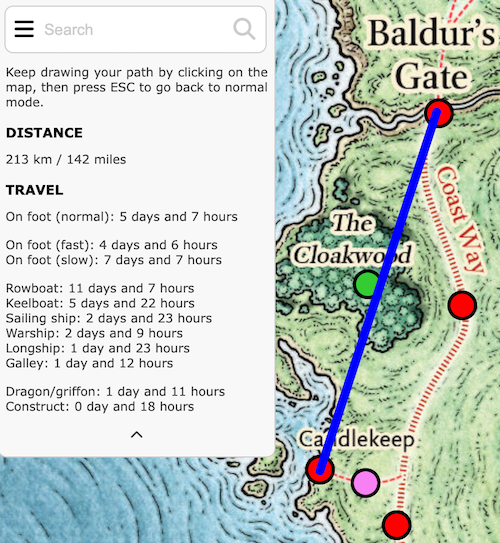
Getting from Baldur's Gate to Candlekeep is fairly simple, there's only really one turn. Head south on the Coast Way until you hit the Way of the Lion, and hang a right.
Somehow, it only recently occurred to me that you can add multiple waypoints to the travel path in AideDD's Atlas. Click once to set the first location, twice to set the first stop, then a third time to set the next, etc. It will happily calculate the distance between the points you've added. Just. Keep. Clicking.
So what do you get when you zoom in and rabidly click to add points that exactly follow the roads your adventurers are likely to follow when following the Coast Way from Baldur's Gate to Candlekeep? An accurate estimation of distance, that's what:
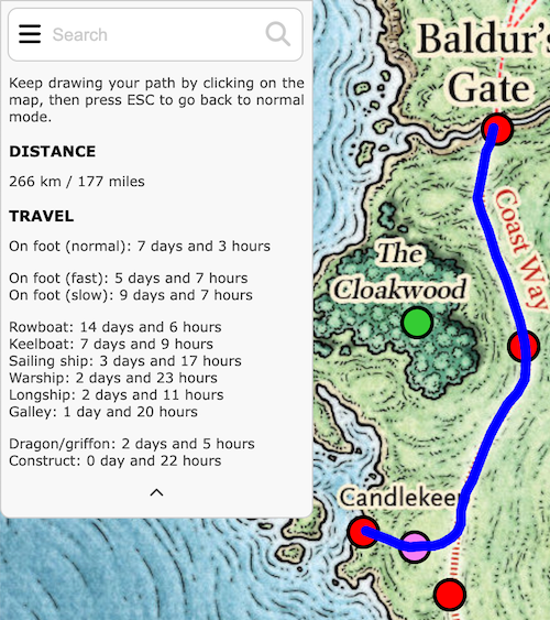
It's like Google Maps for Faerun! It's just so... tantalizing to have this information so close, and yet not close enough to hand to use it at-a-glance. I will continue to use this interactive map for all sorts of reasons, as I always have, but what I realized was that I wanted a travel matrix, so I could quickly look-up the distance values between common locations.
But who has two thumbs and would be nutty enough to put in the work to do such a thing? <points thumbs at chest> This Guy.
Here's how I did it.
A Method to My Madness #
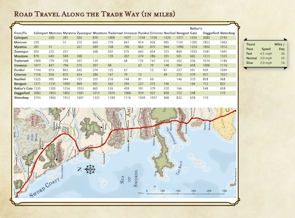
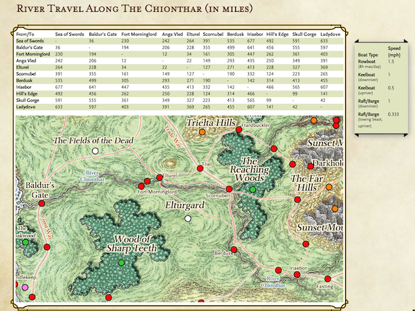
- Pick a route. I decided to pick two common trade routes: The Trade Way, and the River Chionthar.
- For each route, list all of the major stops.
- Start at one end, and call it mile 0.
- For each stop, rabidly click on the map to follow the route to the next stop, and note the distance in miles.
I ended up with a table like this:
Calimport, 0mi
Memnon, +230mi
Myratma, + 51mi
Zazesspur, +221mi
Mosstone, +368mi
Trademeet,  +139mi
Imnescar, +68mi
Purskul, +67 mi
Crimmor, +12mi
Nashkel, +69mi
Beregost, +146mi
Baldur's Gate, +164mi
Daggerford, +548mi
Waterdeep, +110mi
This I fed into ChatGPT in order to generate a markdown table showing the pairwise distances between these common stops along one of Faerun's biggest trade routes.
With just a little formatting in Homebrewery, I'm quite pleased with the result:
Probably, for most people, this is totally unnecessary. But if you're anything like me, perhaps you'll find it a useful addition to your GM binder.