
Forgotten Realms Travel Matrix - The Sea of Swords
During my previous work on travel matrices, I discovered that I'd never really stopped to consider how sea trade would logically work in the Realms' Sword Coast region. Obviously there's plenty of trade going on, to support large cities like Waterdeep, Baldur's Gate, and so forth, but I realized I had no mental model for how that traffic would circulate, and what the likelihood of chartering a boat for any given destination should look like.
But wait, this is the Forgotten Realms. Surely, Ed Greenwood has covered this somewhere, somewhen, right?
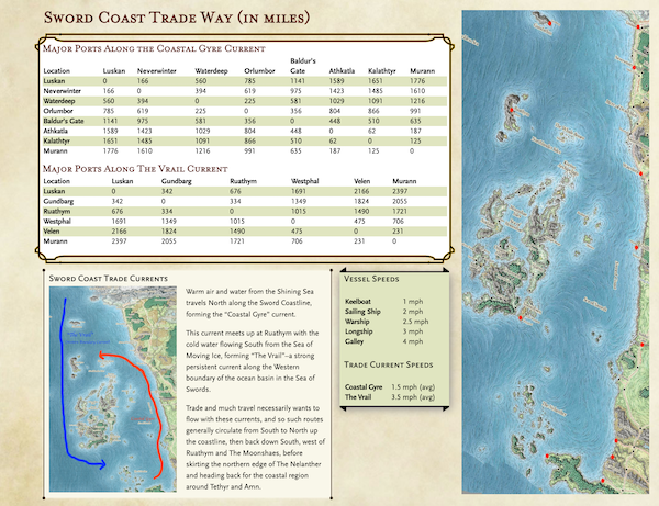
Indeed, a few brief Googles later, I discovered that yes, he had, back in 1979!. Ed's primary western boundary current even gets a cool name, "The Vrail". Because of course it does! This is a cold, deep, and fast persistent current that runs from North to South, along the West edge of the Moonshaes, then curls back in towards Tethyr and Amn. A smaller, shallower current carries warm water and weather "up" the coastline from South to North, getting as far as Waterdeep before circulating back toward the West.
Given this, travel and commerce is going to "want" to circulate counter-clockwise. Now, how fast are these currents? I couldn't find any details. (If you do so, please let me know!) But I can make an educated guess. Our average Gulf Stream current speed is 4mph. Assuming The Vrail to be slightly less powerful, we can set this to be, say, 3.5mph. The warm Coastal Gyre current is weaker. Let's say 1.5mph on average.
Do these numbers make any sense? Well, it's about 650 mi from Waterdeep to Baldur's Gate, going South, against the Coastal Gyre current. Assuming we're on a Galley with full crew and sail, and the winds support this, we'd average 4 - 1.5 = 2.5 mph traveling in this direction. In actuality, tacking against the prevailing winds would likely result in a slower pace, but let's ignore that for now.
650 mi / 2.5 mph = 260 hThat's about 4 hours short of 11 days straight sailing.
On the other hand, it's about 1900 mi from Waterdeep to Baldur's Gate slingshotting around The Vrail. That's almost 3x the distance! But our average speed will be much higher, 4 + 3.5 = 7.5mph.
1900 mi / 7.5 mph = 253.33 hIt's faster by almost 7 h to travel the long way around! So yeah, I guess all other factors being equal, these current speeds could make rough sense, economically.
Hemispheric confusion #
On Earth, such boundary currents circulate counter-clockwise in the Southern hemisphere, and clockwise in the Northern hemisphere. This would imply that the continent of Faerun is situation in the Southern hemisphere, or was in 1979 when Ed first wrote about them. As of 2e, it would appear that Faerun is in the Northern hemisphere of Toril. It would be interesting to know if the continents of Toril have "drifted" cartographically across editions. Not to mention Sunderings. Perhaps someone with deeper knowledge of this lore will tell me I'm being silly and there's a logical explanation for this hemispheric circulation direction oddity.
Establishing Trade and Travel Routes #
Economically, it makes sense to me that merchant vessels would be loath to miss a stop at a trade destination, since coin could be made. Therefore, chartering boats for direct, "point to point" travel would have to compensate the vessel for the potential economic benefit they'd be losing out on. This could potentially be very expensive. Stops at each port are likely to last 6-12h (minimum), with occasional 24h "shore leave" between stops. Let's call it 10 hours, on average, per stop at port.
Googling a bit further to flesh out the likely western stops among the Isles, I decided that my "canonical" trade stops would likely flow from Luskan to Gundbarg, then Ruathym, and around the entire western coast of the Moonshaes to Westphal. The capital city of Caer Callidyr would be a great destination, but it probably doesn't make economic sense to put this stop on the "main route". Instead, dedicated traffic from Tethyr and Amn likely does the bulk of commerce with Caer Callidyr, which also trades with Westphal (and the surrounding Isles). From Westphal, it's on to Velen in Tethyr, then on to the Amnian city of Murann. From there, the Coastal Gyre current can be picked up to follow the shallower coastline route North.
Putting it all together #
Revisting our Waterdeep->Baldur's Gate example, a "likely" route from Waterdeep to Baldur's Gate would incur nine stops, at Neverwinter, Luskan, Gundbarg, Ruathym, Westphal, Velen, Murann, Kalthtyr, and Athkatla. Adding up the milage between all these stops yields about 3592 miles by sea: 560 miles from Waterdeep to Luskan without the benefit of a boundary current (4 mph), 1691 miles from Luskan to Westphal with The Vrail (7.5 mph), then 1341 miles from Murann to Baldur's Gate, with the Coastal Gyre (5.5 mph).
560 mi/4 mph = 140 h
1691 mi / 7.5 mph = 225.5 h
1341 mi / 5.5 mph = 244 h
10 h per stop * 9 stops = 90 h
total: 699.5 h = 29 days, 3 h
Basically, a full month to transit the major trade stops along the Coastal Trade Way. Chartering a normally north and westbound vessel southbound to Baldur's Gate is going to involve compensating the crew for the lost trade with Neverwinter and Luskan, minimally. There might be some vessels dedicated to this "against the flow" traffic, since Waterdeep and Baldur's Gate are major cities, but they'll be at a price premium.
(original map art by Mike Schley)